Van Buren County Iowa
American Guide Series
Compiled by workers of the Writers' Program
of the Work Projects Administration
in the State of Iowa
FEDERAL WORKS AGENCY
JOHN M. CARMODY, Administrator
WORK PROJECTS ADMINISTRATION
F. C. HARRINGTON, Commissioner
FLORENCE KERR , Assistant Commissioner
GEORGE J. KELLER, State Administrator
Sponsored By
The Van Buren County American Legion

Book Cover
[click to view]
Book Cover
[click to view]
page 2
Dedication
Just one hundred years ago, towns were being founded in Van Buren County and settles were building log homes in wilderness communities west of the Mississippi River. There were cabins and stores in all of the communities before the official act of "laying our the towns," for many settlers found what they sought in the hill and valley land along the Des Moines River, when the section was still a part of the Wisconsin Territory. Bonaparte and Vernon, were platted in 1837 and Bentonsport, Birmingham, Farmington, Keosauqua, Kilbourne, and Pittsburg were laid out as new towns in Iowa Territory in 1839.
This book, sponsored by the Van Buren County American Legion, is dedicated to those' towns that have achieved a century-old maturity. The eye witnesses of the events of the first fifty year's are gone, but the stories they told are now historic lore. Some of the events that stirred them have been forgotten, but many are recorded in this book.
The centennial celebrations held in several towns in the county in 1939 turned the eyes of the residents to a proud contemplation of the past. At Keosauqua the men grew beards styled in pioneer fashion; and the women searched the attics and sheds for pioneer relies stored away. Thousands of people visited the old Courthouse at Keosauqua to see the exhibits gathered from all over the county, and walked up and down Main street to see the pioneer displays in the windows . At Bentonsport, the annual home coming day became a centennial celebration with former residents flocking to the town from distant points. Centennial events are now recorded ill the county's history and the people look calmly ahead to the second hundred years, confident that the future will hold good things in store.
page 3
Van Buren County
I. THE CONTEMPORARY PICTURE
Van Buren County Today
Transportation and Communication Places to Play
Places to See
II. IN RETROSPECT
Indian History
Organization of Van Buren County
The Church and the School in Van Buren County
Border Disputes
The Infidel Colony
Navigation on the Des Moines River
Steamboating on the Des Moines River Flood of 1851
The Mormons in Van Buren County
Anti-Horse Thief Association
Railroads in Van Buren County
Underground Railroad in Van Buren County
Negroes in Van Buren County
Van Buren County in the Civil War The Guerilla Raids
Van Buren County in the Spanish American War
The Bonaparte Dam
The Flood of 1903
The Farm Bureau
Place Names in Van Buren County
III. THE TOWNS
Bentonsport
Birmingham
Bonaparte
Cantril
Douds
Farmington
Keosauqua
Milton
Mt. Sterling
Selma
Stockport
IV. THE AMERICAN LEGION IN VAN BUREN COUNTY
History of the County Legion
History of the Local Legion Posts
The Legion Roster
page 4
The Contemporary Picture
VAN BUREN COUNTY TODAY
Van Buren County is peaceful and has a feeling of self-sufficiency. Most of the people. bound by deep-rooted associations, have a loyalty to this southeastern section of Iowa. It was their ancestors. attracted by the wooded shores of the Des Moines River flowing through the county at its broadest and best, by the hills, the valleys, and the rolling lands, who stopped to build homes and towns in the wilderness rather than to push on to the north and west.
Although the towns along the river aspired in their youth to a noisy industrial adulthood, many of the villages away from the river were satisfied to be villages, the marketing-and meeting-places for the farmers in the surrounding country. It was these villages to which the mothers and fathers could retire after years of hard labor, leaving the management of their farms to sons, or, in recent years, to renters. When quiet life came to the river towns that had once teemed with the promise of industrial growth, those who remained accepted it without any great sense of loss. Although the older inhabitants relate incidents of the days when the towns were two or three times their present size, they still have a pride in the progressiveness of their schools, the modern businesses that are putting Van Buren County on the map, the two state parks within its borders, and its sons and daughters who are winning fame.
Van Buren is similar to several of the counties in Iowa where the population of the largest towns does not much exceed a thou-sand. Life has a simpler pattern; hurry and rush do not take their toll of nerves. The people have time to be friendly; time, if they wish, to sit with a fish pole along the banks of the Des Moines and watch the setting sun turn the muddy water to a copper smoothness: time to stand on the small-town street corners and swap stories of the past that have come down from father to son, stories of steam-boating on the Des Moines, the devastating floods, the fishway fight at Bonaparte, and the stealing of Black Hawk's body.
There is a solidarity in the county, since the living and thinking of the farmers and the townspeople are not widely divergent. The townspeople are as interested in the crops, the weather. and the problems of the growing and harvesting seasons as the farmer him-self, so closely connected are their interests. Social life, too, is shared. It's the lucky town folks who can plan on going out to the country to help with the threshing or corn husking dinner; and the farmer and his family look forward to the church supper in the village.
Van Buren County, named in honor of the eighth President of the United States, situated in the extreme southeastern portion of Iowa is one county removed from the Mississippi River to the east,
page 5
and is bordered on the south by the Missouri state line. According to the Federal Census (1930), 12,603 persons reside in the fourteen townships with their total area of approximately four hundred and eighty square miles. More than half the population lives in rural sections.
The rolling prairie stretches of the valley of the Des Moines River, which flows diagonally through the county from northwest to southeast are well adapted for farming, dairying and livestock raising, their principal industries. Only about eight hundred acres of the total county acreage are listed as untillable, and only the rolling land back of the river and along the numerous creeks is subject to rapid erosion. The Des Moines River and its numerous tributaries, the Fox and the Little Fox Rivers in the southwestern part, and the Little Cedar Creek in the northeast, afford ample drainage.
The Des Moines, in Van Buren County, is a river of varying moods, flowing north, south, east, and west before it becomes the boundry line between Missouri and Iowa. Almost in the heart of the county, it loops itself into a great horseshoe bend within which lies Keosauqua, the county seat and the second largest town. Just across the bend from Keosauqua, is Pittsburg, a hamlet that is practically a suburb of the county seat, since the two are connected by a short stretch of road known locally as the Long Lane because it winds through a pleasantly wooded area, ideal for a Sunday afternoon stroll. Phil Stong, author, who grew up in this neighbor-hood, used the name and the locality as the setting for his novel, The Long Lane (see Points of Interest, Pittsburg),, published in 1939.
Along most of its way through the county, the river flows between wooded bluffs, broken occasionally by rocky cliffs, or the mouths of numerous creeks. It is crossed by bridges at Keosauqua, Bonaparte, Bentonsport, Pittsburg, Farmington, Douds, Kilbourne and Selma.
In the spring, on the highways that parallel the river or follow. the crest of the bluffs, midst the green of the white oak, linden, elm and hickory trees of the upland, the "sarvis" berry blossoms in orchid, the wild crabapple in flaming pink, and the wild plum and cherry in snowy white. Black and white walnut, sugar maple, ash, cotton wood, honey-locust, mulberry, hackberry and sycamore trees, many of them very old, grow along the river bottoms. On the J. C. Featherstone farm near Mt. Sterling are two cottonwoods, one six feet in diameter and 240 years old, the other five feet six inches in diameter and 210 years old, and a burr oak five feet in diameter, 99 feet in height, with a bough spread of 100 feet.
In the prairie reaches, good water is procured by means of wells at depths of twenty to thirty feet. Although it is more difficult to obtain a water supply along the river bluffs or in the timbered land, most families sink the deeper wells when it is necessary and make
page 6
general use of cisterns.
According to estimates, three-fourths of the entire area is underlaid with coal formations, but it is improbable that workable seams would be found extending under more than one-half of this territory. The best outcroppings are on the southwest shore of the Des Moines River, where a little coal is mined.
During the glacial period the entire county of Van Buren was covered by the Kansan drift, which reached to a depth of fifty to one hundred feet, being somewhat thicker in the southwestern part of the county than in the northeastern part. Entirely within the southern Iowa loess soil area (or area of wind-blown deposits), the loess soils found here are of the Clinton, Grundy, Marion, and Lindley series. The four terrace soils belong to the Calhoun, Jack-son, and Buckner series with the Calhoun silt loam the most extensive. The four swamp and bottomland soils -found are all included in the Wabash series and cover only a small area of the county. A drift soil in the county, known as the Shelby loam, covers 5.9 per cent of the total area of the county and is found mostly in the southwestern and southern parts.
The county towns, Bentonsport, Birmingham, Bonaparte, Cantril, Douds, Farmington, Keosauqua, Milton, Mt. Sterling, Mt. Zion, Selma, and Stockport, with populations ranging from one hundred to one thousand, are primarily trading centers for rural areas in their vicinity.
Every town and rural district has its church with at least two denominations represented in each town. Some of the churches that lift white spires above the trees give a flavor of New England to the villages, and indicate that many of the earliest settlers were from that section. There are Baptist, Catholic, Nazarene, Congregational, Methodist, and Presbyterian churches in the county, with Methodist churches the most prevalent. In 1935 a small group of pastors met at the home of Reverend D. D. Flanagan, then pastor of the Federated Churches of Bonaparte, and organized the Van Buren County Ministerial Association. Including in its member-ship minsters of all denominations and their wives, the Association meets regularly in various towns of the county.
There are numerous rural and elementary schools in Van Buren County, and accredited high schools in Birmingham, Bonaparte. Cantril, Douds, Farmington, Keosauqua, Milton, Selma, and Stock-port.
TRANSPORTATION AND COMMUNICATION
Highways through Van Buren County climb hillsides, follow valleys, and skirt the Des Moines River, providing views whose charm changes with the seasons.
Traversing the southern part of the county from Farmington at the eastern border, through Cantril to Milton at the western border, is State 3 (paved). State 1 (paved or graveled) connects Birm-
page 7
ingham, in the extreme north central portion of the county, with Mt. Zion and Keosauqua, the county seat, in the central section, terminating at its junction with State 3, four miles south of Keosauqua. North of Keosauqua, State 3 follows the Horseshoe Bend of the Des Moines River. State 16 travels a general east to west course in the northern part of the county to link State 1 -with the Coleman Highway in Lee county to the east. From its junction with State 1, State 16 parallels the Des Moines at a distance of about three miles. State 114 runs south from Farmington to the Missouri line; and State 79 (paved) links Bonaparte with State 3.
The secondary roads (county roads) are surfaced with either gravel or crushed rock. Following the secondary river roads, which cross and recross the Des Moines, and the state highways, the visitor can see the hills, valleys, river views, and attractive countryside that Van Buren County folks talk about even when they are far away.
The main highway bridges spanning the Des Moines River have an average length of seven hundred feet and an average width of twenty feet. All are high above flood level.
Two branches of the Chicago, Burlington and Quincy Railroad and one branch of the Chicago Rock Island and Pacific Railway have a combined trackage of eighty miles within the county.
In 1938 there were fifty-one independent telephone lines in the county with a total of seven hunched and twelve miles. Four electrical transmission companies had a total of nearly one hundred and forty miles of lines.
PLACES TO PLAY
STATE PARKS: Farmington and Lacey-Keosauqua State Parks (see Farmington and Keosauqua, Points of Interest).
GOLF COURSE: Nine-hole course in Lacey-Keosauqua State Park (public; membership $10; visitors, 40c Sun. and holidays, 45c week days).
SWIMMING: Anderson's Park (private), one and one-half miles north of Keosauqua, on the Des Moines River; Lakes in Lacey-Keosauqua and Farmington State Parks (public; free).
BOATING AND CANOEING: Along Des Moines River, especially at Keosauqua; Lake in Lacey-Keosauqua State Park; Anderson's Park.
FAIRGROUND: One mile north of Keosauqua; Van Buren County Fair (held in early September-in 1939, Sept. 5-8).
ATHLETIC FIELDS: Baseball diamonds at county fairgrounds and at Farmington, Bonaparte and Stockport.
COMMUNITY CENTER: Keosauqua.
page 8
At Bentonsport
Mason House
Hancock House
Post Office
Presbyterian Church Bentonsport Academy- Building
Vernon
At Birmingham
Old Rail Fences
Grave of Mrs. Mary Ann Rutledge
At Bonaparte
Old Dam Lock
The Ferry Tree
Mormon Burying Ground
Grey Heath Orchard
At Farmington
Grave of Rebecca Pollard
Farmington State Park
State Line House
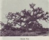
At Keosauqua
The Old Church Tree
Courthouse Van Buren County
Bonnyview
Franklin Pearson House
Hangman's Hollow
Ely Ford Mounds
Lacey-Keosauqua Park
U. S. Forestry Service Nursery
Pittsburg
Point on the Military Road
At Mt. Zion
Kilbourne
At Selma
Iowaville and Black Hawk's Grave
Old Log Cabin and Piano
At Stockport
Rock Haven
Masonic Hall and Anti-Horse Thief Building
Point on Mormon Trail
page 9
In Retrospect
INDIAN HISTORY
Indians were still in Van Buren County during the Wisconsin and early Iowa territorial days. The site of Iowaville, an early Van Buren county village, was part of the 1,250,000 acres of land that the Sac and Fox Indians had sold to the United States Government, reserving two years time on the land. James Jordan, William Phelps, and James Tolman bought the Indians' lease in 1837 for $3,000. Most of the Indians vacated the land in the spring of 1838, at the time the town was laid out, but Black Hawk and a few of his followers remained. Jordan, who had been in the vicinity since 1828, established a trading post.
lowaville is on the site of what was once the chief village of the Iowa Indians. Although historians doubt that any great Indian battles were fought in the state, Van Buren County folk still believe the tale of the battle between the lowas and the Sac and Fox. Ac-according to the story, one of the decisive Indian battles in Iowa, transferring the sovereignty of the Des Moines River valley from the Iowas to the Sac and Fox Indians, was fought in this north-western corner of Van Buren County just outside the Indian village. Although the exact date is not known, James Jordan, a trader who visited the battlefield in 1828, said the graves of the slain still appeared fresh, as if they had been made not more than a few years before. The battle was probably fought before 1825, however, since the Iowa Indians at that time sold a part of their claim in the Des Moines River valley to the United States Government.
This chief village of the Iowa Indians on the Des Moines River was at the lower end of the river bottom prairie that extended along the river about four miles, and inland two miles. The prairie lay about twenty feet above the river. The lowas had a natural game field about two miles above their village. They often gathered at a small natural mound, covered with shrubs and trees, which stood almost in the middle of the prairie where they had established a race track. Another belt of prairie, covered with a rank growth of grass, reached from the mound to the abruptly rising, heavily forested bluffs. On the day before the battle, unknown to the lowas, a Sae and Fox war party approached the village through this forest on the bluff, and from their hiding place watched the unsuspecting Iowas.
Not knowing an enemy was near by, the Iowas left the women and children in the village and rode off to their playground. Anticipating only the exciting horse races, most of the warriors left their weapons in the village. In the midst of the races, half of the war party swooped down from the bluff and attacked the group while another party of the attackers swerved around to the village, slaughtered most of the women and children, and burned the village.
page 10
For a time most of the Iowas lived as part of the Sac and Fox nation, but the subjugation was galling to some. In 1825, at their request, the United States Government purchased part of their claim in the Des Moines River valley. A scattered few, scarcely maintaining an existence as an independent tribe, continued to live in the vicinity; but the more recalcitrant located on the Little Platte River in Nebraska. In 1829 they still laid claim with the Sac and Fox to land west of the Mississippi, but at this time there were only about a thousand Iowas left.
ORGANIZATION
Originally Van Buren County was a tiny portion of that vast area taken from the Indians by the French and bought by the United States as the Louisiana Purchase of 1803. Iowa was included in the Territory of Illinois in 1807 and in the Territory of Missouri in 1812. In 1824, after the Black Hawk Purchase, all of the territory west of the Mississippi and north of Missouri was made part of the Territory of Michigan. The same year (September, 1834) the legislature of Michigan established two counties in what is now Iowa. These were Dubuque, comprising all the territory north of a line drawn westward from the foot of Rock Island, and Des Moines, including all territory south of the dividing line. After Iowa was made part of the Territory of Wisconsin, the county was divided into six counties. Van Buren extended westward to the Indian Boundry line, which lay fifty miles west of the Mississippi River, and had been established by a treaty with the Sac and Fox tribes on September 21, 1832.
In 1837 the Wisconsin Legislative Assembly designated Farmington as the county seat of Van Buren, but with the growth of new towns, competition sprang up among the communities for possession of the county seat. Finally in May, 1829, Keosauqua was made the county seat of Van Buren.
THE CHURCH AND THE SCHOOL IN VAN BUREN COUNTY
Almost as soon as Van Buren County was settled, the people formed small churches. They heartily welcomed itinerant ministers, and drove miles to hear a "preaching." Latch strings were always out for ministers of any denomination.
In 1837, while Iowa was a part of the Wisconsin Territory, the first church service in Van Buren County was held under the up-lifted branches of an old elm tree on the banks of the Des Moines River, not far from the present site of Keosauqua (see Keosauqua, Points of Interest). Almost one hundred settlers gathered that (lay to hear the simple service conducted by the Reverend Hill, a Baptist preacher. Black Hawk, chief of the Sacs, then living at Iowaville, is said to have been among the listeners.
Religious spirit was strong in every community from the be-ginning. The settlers crowded eagerly into one-room log-cabin
page 11
 Church Tree
[click to view]
homes, schools, barns, stores, and public buildings to hear services. Some of the first churches, such as the Bethel Free Methodist Church near Selma, were log buildings open to all denominations. At Keosauqua, in 1836, Elijah Purdom erected a double log cabin that was used for religious services as well as his home, and two years later, nearby settlers organized the first Christian Church. Under the leadership of Rev. Solomon Cole, the Presbyterians held their first meetings in 1839 in a barn in Birmingham; and in the same year United Presbyterians organized their first church in the same town. The Baptists founded their church at Farmington in 1841; the Congregationalists established theirs nineteen years later at Bentonsport.
Within a decade after the first church service was held in the county there were half a dozen denominations represented by thirteen established churches. Even an infidel colony (see Abner Kneeland's Grave, Points of Interest, Farmington) had flourished and died.
The first school was organized at Farmington in 1834, while the land was still a part of Michigan Territory. Before the third Iowa Territorial Legislative Assembly enacted a school law and selected a Superintendent of Public Instruction in 1841, schools had already been established in Birmingham (1838-39) Keosauqua (1840), and Mt. Sterling (1841).
Church Tree
[click to view]
homes, schools, barns, stores, and public buildings to hear services. Some of the first churches, such as the Bethel Free Methodist Church near Selma, were log buildings open to all denominations. At Keosauqua, in 1836, Elijah Purdom erected a double log cabin that was used for religious services as well as his home, and two years later, nearby settlers organized the first Christian Church. Under the leadership of Rev. Solomon Cole, the Presbyterians held their first meetings in 1839 in a barn in Birmingham; and in the same year United Presbyterians organized their first church in the same town. The Baptists founded their church at Farmington in 1841; the Congregationalists established theirs nineteen years later at Bentonsport.
Within a decade after the first church service was held in the county there were half a dozen denominations represented by thirteen established churches. Even an infidel colony (see Abner Kneeland's Grave, Points of Interest, Farmington) had flourished and died.
The first school was organized at Farmington in 1834, while the land was still a part of Michigan Territory. Before the third Iowa Territorial Legislative Assembly enacted a school law and selected a Superintendent of Public Instruction in 1841, schools had already been established in Birmingham (1838-39) Keosauqua (1840), and Mt. Sterling (1841).
page 12
In 1841 Van Buren County elected inspectors who divided the, townships into school districts. In some of the county districts, the people favored township organization; in others, they thought the, villages should become independent districts as soon as they could fulfill the requirements. Eight independent districts were finally formed in 1847, and a building program begun that increased the valuation of the county's school buildings by $50,000.
During Iowa's territorial years, "the school situation was deplorable because the territory had so little money. The building of schools was discretionary and the people used more discretion than money." There were no schools for five-sixths of the children, and these had to depend on their parents for their education. George C. Duffield of the Chequest settlement, Van Buren County, in his book, Youth Time In Frontier Iowa, describes the typical "teacher" of that period in these words: "The mother's left hand holds an old worn Webster spelling book, and the other holds a flickering tallow candle." After the day's work was done, the children sat around the fireplace learning from their mothers, who tried to take the place of dictionary, encyclopedia, and thesaurus.
For at least a decade following the territorial period, the teachers in Van Buren County "boarded around," and collected pro rata from their pupils. During this period, $24 per year, plus hoard and room, was considered a fair wage. The text books used were at first a heterogeneous collection acquired from various sources, but as the public school system developed, McGuffey Readers, Ray's and Colburn's Arithmetic's, Weel's and Green's Grammars, and Webster's Speller were used.
Most of the boys and girls first trudged to log schools, and dangled their feet from crude log benches as they balanced their slates on puncheon desks. Although these public subscription schools were numerous, private academies also flourished during the 1840's and 1850's (see Towns).
Van Buren County was one of the leaders in the establishment of public schools, and in 1858 Anderson McPherrin was chosen first county superintendent. In 1871 private academies and collegiate institutes began to give way to the rapidly growing public schools. The first Van Buren County Teachers meeting was held at Keosauqua from August 7 to September 2, 1867, and called the Teachers Training Academy. At that time about seventy-five men and one hundred and fifty women were teaching, the men receiving higher salaries. In 1885 an institute was again held at Keosauqua high school. Board cost $3 a week in private homes and $2.50 for five days at the Russell House. At these meetings each teacher was required to bring a class from his school and conduct a recitation. At the evening session teachers, pupils, and parents gathered together to hear a lecture.
page 13
BORDER DISPUTE
The ripples in the Des Moines River near Keosauqua were the cause of the "Honey War," the boundary dispute between Missouri and Iowa.
In 1816. J. E. Sullivan, a government surveyor. had established the Northern boundary of the Territory of Missouri, mentioning the "Rapids of the Des Moines" as one of the boundary marks.
In 1S37 the State of Missouri appointed commissioners to re-survey the Northery boundary. The commissioners found ripples in the Horse Shoe Bend near Keosauqua. in the Des Moines River, which they assumed to be the "Rapids of the Des Moines" named in the Act of Congress defining the boundary. These ripples, however, had never before been called the Rapids of the Des Moines. The real Rapids are in the Mississippi River, extending from the confluence of the Des Moines with the Mississippi, about eleven miles upstream, to the town of Montrose.
The conflict over the disputed territory-a strip about eight miles wide, just below Keosauqua - began when Clark County, Missouri placed the names of the citizens in the territory on its tax list. When the Missouri officers tried to collect the taxes for Clark County. the settlers in the disputed section refused to pay them, and when the sheriff tried to collect the delinquent taxes, he was arrested on a warrant issued by a magistrate of Van Buren County, and clapped into jail at Muscatine.
About this time a Missourian cut down three bee trees on the disputed tract and the Iowan who owned the trees had him arrested and tried before an Iowa Magistrate. A judgment for one dollar and fifty cents was rendered against the Missourian, and the term "Honey War" was applied locally to the conflict.
The arrest of their sheriff so angered the Clark County citizens that they petitioned Governor Boggs of Missouri for military aid. The Governor called out the militia of one thousand men to help the Clark County officers collect the tax.
Governor Lucas of Iowa then called out the Iowa militia, in which many citizens of Van Buren eagerly enrolled. In a short time about six hundred men were camped in Van Buren County and six hundred others were on their way.
Before hostilities could begin, however, a delegation was sent to Governor Lucas to settle the controversy peacefully. Missouri with-drew her troops and the Iowa militia was disbanded.
General A. C. Dodge of Burlington, General Church and Dr. Clark of Fort Madison were sent to Missouri to settle the dispute. Upon their arrival they found that the County Commissioners of Clark County, Missouri had rescinded their order for the collection of taxes, and that Governor Boggs had dispatched messengers to Iowa who proposed submitting the case to the United States Supreme Court. Is 1848 the United States Supreme Court voted in
page 14
favor of Iowa. William B. Miner of Missouri and Henry B. Hendershot were appointed commissioners to resurvey the boundary line and mark it with an iron post every ten miles. One of these posts may still be seen a mile and a half below Farmington, on the west bank of the Des Moines River.
The trail followed by the militia is marked by a stone monument (see Points of Interest, Keosauqua).
THE INFIDEL COLONY
The only infidel colony in Iowa territory was in Van Buren County, in a settlement about two miles south of Farmington, known as Salubria. In 1889 Abner Kneeland came to the territory and started an atheistic movement. Kneeland began in Boston as a Universalist minister, but became so liberal that his church cast him out. He then styled himself a pantheist and his enemies called him a pagan. He was finally arrested for blasphemy and thrown into prison. That stirred Boston. Ralph Waldo Emerson and many others protested against such a procedure. Released from prison, Kneeland formed a colony to find freedom in the West-in Van Buren County, Iowa. The settlement was named Salubria, meaning health. Orthodox preachers were excluded from the community. For a time Salubria prospered, and its doctrines spread to other places. Kneeland himself became enough of a political factor to split the Democratic party into "church" and "infidel" factions in 1840 and again in 1842, when he ran for the territorial legislature. Perhaps his political activities contributed to his undoing. Salubria did not endure as an atheist colony, but after Kneeland's death gradually became a comfortable farming community, with orthodox religious sentiments (see Abner Kneeland's Grave, Points of Interest, Farmington).
NAVIGATING THE DES MOINES
In the early days the Des Moines was a deep swift river. In the fall of 1837 the few settlers along the river in Van Buren heard for the first time the hoarse whistle of a steamboat on that river. The S. B. Science, commanded by Captain Clark, had made its way against the swift current, passed safely over the hidden rocks and sandbars and proved conclusively that the Des Moines, at high water, was navigable. The steamboat carried supplies for the trading posts in Wapello County, where the Sac and Fox Indians had recently settled. By the treaty of 1842, the Sac and Fox tribes sold all their lands in Iowa, but retained possession for three years of the territory west of Red Rock. They moved up country and settled near the Raccoon Forks, where the Federal Government at the same time set up a fort. Edwin Manning, of Keosauqua, had the contract to supply the fort with provisions. He chartered the little steamer lone at St. Louis and brought the provisions, as well as the soldiers
page 15
and their equipment, to the landing, the site of the present city of Des Moines, on May 9, 1843.
To celebrate this second successful navigation of the river, Manning gave the army officers and the Indian chiefs a free ride on the Ione. Then the Indians in turn wished to honor Manning, and sent couriers to the head men of the Nations requesting the tribes to come at once to pay their respects to the captain of the Ione. The tribes arrived in magnificent array, and three hundred Indians gave a stirring performance of their ceremonial war dance.
Popular sentiment was in favor of developing the Des Moines as a commercial waterway, and in 1846 Congress passed an act providing that land on each side of the river be set aside for this improvement, but ten years of legislation, litigation, controversy, and work begun and abandoned, accomplished little in this direction. During this period Edwin Manning introduced flat-boating, which proved successful in commercial transportation on the Des Moines. Steamboat men were still reluctant to risk their boats on the river; the occasional mill dams made passage dangerous. In 1858, the steamboat Colonel Morgan, after getting through the locks at Keosauqua, turned over a short distance above the dam and sank.
STEAMBOATING ON THE DES MOINES
The number and variety of boats on the river increased every year. Since Mississippi River steamboats were too large for the Des Moines, smaller boats were built that could maneuver through narrow channels, circle abrupt bends, surmount dams, glide over sandbars and hidden rocks and navigate in the "pint o' water" that river pilots declared was all a dry season often left in the river bed.
Keel-boats, which were boats with a keel but no sail, transported most of the freight up the river. Steamboating on the Des Moines began about 1837, when Aaron W. Harlan brought the first steamboat to Keosauqua. In 1838 a heavily laden keel-boat, owned and commanded by Captain Cash, made its appearance at Keosauqua. The boat, which had been loaded at Keokuk, carried flour, corn-meal, a small cargo of dry goods, a few barrels of whiskey, and Indian supplies. Captain Cash made a handsome profit on his cargo. The keel-boat made many trips up the river, despite the fact that it often had to be pushed against a swift current with "setting poles."
The steamboats blew their whistles as they neared their landing places, and the people on shore would leave their houses, stores. and offices to gather at the river. The moment the boat shoved out its gangplank everyone would rush aboard. Even a religious service could not restrain the excitement aroused by the sound of a steam-
page 16
boat whistle. One Sunday evening in May, 1858, "at very candle lighting," the John B. Gordon hove into port. It was met the wharf by the woad throng, for all the worshippers had slipped out of churches at the first, sound of the whistle from far down the river. The sextons and everyone else had headed for the landing without waiting for the benediction, leaving the ministers to put out the light:. and if they wished---to follow more sedately.
The year 1858 was a great year for steamboating on the Des Moines. From April to August it rained heavily enough at just about, the right, intervals to keep the river high. According to some of the old settlers at Keosauqua the redbirds, which came up from Missouri in great numbers, sang in the branches of the trees along the Des Moines, "Wet, wet year! Wet! Wet! Wet!" During. some weeks a boat arrived and departed nearly every day.
The water was deep enough to satisfy the most cautious steam-boat pilot, but there was still trouble with the locks and dams. Edwin Manning opened the way to free navigation through one of the obstructions at Farmington. In the early spring he chartered the Jenny Lind, which with its accompanying barges, was loaded with goods for up-state Iowa. Reaching Farmington, and finding the dilapidated water gates a menace to steamboating, he tore them out and set them adrift.
Sometimes boats could not get past the dam at Keosauqua. This was especially true of stern wheelers, for when the wheel was above the point where the water broke over the edge of the dam, it did not touch the water, but flew around with great velocity, threatening a serious break in the machinery and a sudden cutting off of the power that, propelled the steamer, When that point was reached, the boat fell rapidly back into the swift current below the dam, and was with difficulty brought over it again. The steamboat, G.H. Wilson, however, was a powerful boat with a dauntless captain, The dam at Keosauqua was in its most, forbidding condition. The boat struck again and again and each time fell back. In desperation, the' captain ordered the engineer to get the steam up and open the throttle wide; then giving his command so that it could be heard half a mile away, he roared, "Send her over--or blow her to hell!" Amid the cheers of the spectators, the boat went over-although the engineer said, afterwards, that he had rather expected the alternative.
Sometimes low water held a boat up for days. One of the most tricky stretches along the river in any season was a series of curves known as "Rattlesnake Bend," and whenever a boat struck the spot-during a dry spell it had to be "worked" through by means of ropes fastened to trees, stumps, and snags in and alongside the river, and by employing the capstan or even man-power to draw her up in
page 17
places where steam could not be used. Sometimes it took a day to get through this difficult passage.
Many boats went up the. river. The S. B. Science was the first steamboat on the Des Moines. The Jennie Deans was a big St. Louis packet and the Jenny Lind plowed through the old water gates at Farmington The Flora Temple, "a side wheel three decker," was the largest steamboat ever to reach the Des Moines. She was called the "rope-cutter," because she ignored ropes stretched across the river to operate the ferry boats and cut them without warning if they interfered with her progress. The Alice was a favorite boat, carrying passengers as well as freight. The Michigan was one of the smallest freight boats. The Pandoging, a nondescript craft, was built by its owner, Captain Sweazey, somewhere between Keosauqua and St. Francisville. Sweazey owned a sawmill on the Des Moines River from which he took the engine for his boat, but it was too weak and made the boat "yaw" from one side to the other. The craft had no rudder, but was steered by the captain's son, who stood down in the dark hull guiding the boat with a long plank as his father roared directions from above: "Swing to the left-to right-straight ahead." The captain, the craft, and the crew were a source of much amusement to steamboat men.
The Skipper carried men of the General Assembly of 1858 home from Des Moines when the roads were too had for stage travel. The Maid of Iowa was the only boat to navigate "Soap Creek"-without at all wishing to do so, however. The George W. Wilson was said to be the most powerful boat that was ever on the river.
In 1861 the "Des Moines River Steamboat" fleet had been narrowed down to three boats: the Ada Hine, the Des Moines Belle, and the Des Moines City. The Civil War had begun and all boats that could carry freight and passengers were engaged in transporting troops in southern waters. The three boats left on the Des Moines were kept busy.
In 1862 Adjutant General Baker commandeered the entire line of steamboats then running to Des Moines from Ottumwa for carrying all wounded, disabled, or discharged soldiers to their homes on the upper river. The boats making regular trips were the Des Moines Belle, the Des Moines City, Little Margrave, the Alice, and the Clara Hine.
Steamboating on the Des Moines River virtually ended in 1862. The railroads were coming nearer, making steamboating ever more uncertain and unprofitable; and the simultaneous need for boats to transport troops and supplies in the south attracted nearly all the remaining river captains.
The Des Moines River played its last part in the life of Iowa in 1894, when "Kelley's Army," consisting of a thousand unemployed men on their way to Washington, D. C., to present President Cleve-
page 18
land a "petition in boots," arrived in Des Moines. Temporarily without means of transportation, the men seemed ready to stay on in the comfortable city-when it occurred to the city officials to build flatboats. on which the army departed down the river.
By 1850 the banks of the river had begun to wash away, and the flood of 1851 hastened the process. In 1890 the bed of the river began to fill in, and the willows that had once been uprooted from the river banks grew thickly again. The Des Moines had now become merely a brook that flowed only after heavy rains. In 1938 the War Department found the temporary suspension bridge over the Des Moines "illegal" because the River and Harbor Act of 1899 declares that "no obstruction shall be placed across any navigable river." Van Buren County smiled sadly at the irony implied in "navigable." since the erstwhile route of steamboats had become so parched that "even a good-sized minnow would have to stand on its head in order to drink."
THE FLOOD OF 1851
The Des Moines River had always rushed swiftly along its course, but until 1851 it had never left it. That year, however, the rainfall in Iowa reached the unprecedented peak of 74 1/2 inches. From early March until late June the rain fell in torrents. The upper reaches of the Des Moines were hemmed in by steep cliffs, but at the bends, where the walls were not so high, the water cut across to the next bend, the fierce current ripping up the alluvial soil, undermining the heavy growth of timber, forming temporary dunes, ploughing out strange paths, and carrying the soil to the south to form new channels and new shorelines. When the soil about the roots was washed out, great trees crashed down and floated away in a mad rush. Fish were swept from the regular basin to the ravines and lagoons, where hungry people sought them when the waters receded.
At its highest the water stood 22 1/2, feet above the low water mark and carried away the stored crops, growing crops, and everything that could be moved. Business was at a standstill for five weeks, during which time the waters rose after every rainfall. Merchants kept moving their goods higher and higher upon the shelves, saying, "Surely the water can't go higher." Many of them slept on their counters between sales to customers who came in in boats. Each day, when morning broke, these storekeepers never knew whether their feet would sink in the mud left by the receding river or whether they would have to move their goods to a higher shelf.
Houses left their foundations and joined the crazy procession of sheds, barns, dead animals, brush and trees careening over the
page 19
dark waters. Here and there the debris piled up and when the waters receded the owners tried to salvage what they could from the mass.
There were few disputes, since each man recognized his bit of property--a chicken coop, a bedstead, the shattered remnants of a dwelling, or a broken tool. Thousands of golden ears of corn, worth two dollars a bushel, might have been saved, but were lost in the swirling waters because a grain dealer regarded as just another river joke the warning of four young men travelers that the river would rise three feet before morning.
And one day the settlers beheld a crowd of wooden shoes drift by-five hundred pairs of them, from the unused blacksmith shop in Amsterdam where they had been stored. One observer saw a white pigeon perched atop one tiny wooden shoe as it dipped and rose on its way to the Mississippi.
Not everyone was downcast during the floods. Here and there a young man poling a raft took his sweetheart for a ride, and a larger craft with a group of youngsters on board glided past a sub-merged house, the young voices rising in song above the wreck-strewn waters.
In Iowaville, Joel Avery, a farmer living on high ground, sent a message to his drowned-out neighbors in the lowlands: "Come over and hunk with me. I have a big barn. Everything is at your service." His offer was quickly accepted. The Iowa Hotel and the Keosauqua House, during the flood, moved into their second stories, and guests arrived and left by boat.
The tremendous loss suffered by the settlers could not be estimated in money alone.
MORMONS IN VAN BUREN COUNTY
During the years of the main migration of the Nauvoo, Illinois Mormons to Salt Lake City, Utah there were three trails through Van Buren County made by the Saints. The smallest trail cut diagonally across the northwest corner. This was known as part of the Old Trail from Caldwell, Missouri, made by Saints fleeing from persecutions in the State of Missouri in 1838. The main trail taken by the pioneer group which, led by Brigham Young, left Nauvoo in 1846, entered Van Buren County close to the southeast corner and followed the route of the Des Moines River as far as Keosauqua. From there it turned due west and entered Davis County at about the center line of the western border. The trail of 1853, known as the "Immigrant Trail," because it was taken by people who came from Europe as converts to the faith, entered Van Buren County near the center line of the eastern border and followed the route of the present Burlington railroad. It entered Jefferson County at
page 20
about the center of the northern border of the two counties.
The Mormons left their first camp on Sugar Creek in Lee County on March 1, 1846 and two days later arrived at the Des Moines River. which they crossed at Bonaparte Mills, then traveled on and made a camp on the north fork of Indian Creek. They found this at a place known as B. Ellis' farm-a name later contracted to Ellis' Ford. Leaving their camp there, they continued to Chequest Creek and camped a few days, then followed the creek to Davis County.
They called the camp where the leaders-that is. Brigham Young and the Twelve Apostles who dictated the policies of the group-rested, the camp of Israel. There were from two to three thousand Mormons in the group, with about five hundred wagons. They had a brass band led by Captain Pitt, which many of the villagers of Farmington came to hear.
From Clayton's Journal:
March 3: "We went eight miles and then on through Farming-ton where Bishop Miller was camped. The roads were hilly and muddy, and the company traveled until five in the afternoon. The Quadrille band was invited to play at Farmington. and it took their big carriage an hour and a half to go back the eight miles. The concert lasted until nearly dark and was well attended. The school-house was crowded, and the leading men and women of the place were well pleased. After the concert they gave the band members a supper and five dollars.
"The next day the Mormons broke camp and the company went on to Bonaparte where they crossed the river (Des Moines). Across from the river was a steep bluff which slowed down travel so that by late afternoon they had traveled but 1G miles in all. Eight miles from this camp a Dr. Elbert lived. He came over to see the set of china and a music box which the clerk of the camp. Wm. Clayton. wished to sell, and purchased the chinaware.
"Sunday, many of the people from Keosauqua came to the camp and asked that the band play for 'them in town. President Young agreed that they could go Tuesday afternoon. The camp was at Richardson's Point, about 10 miles from town. The big carriage with the band traveled up and down the main street, stopping to play whenever a storekeeper would ask and pay for a tune. Several grocers called on the leader and finally a beer keeper asked them not to slight him. The band played for cakes and beer. At the Des Moines hotel, near the courthouse, they had their supper and played from seven to nine o'clock, clearing $25.00 over the expenses incident to the trip.
"They returned again the next night, and cleared $20.00. "Upon their return to camp they found a heavy rainstorm had wet all their bedding and supplies and although it was nearly im-
Transcribed by Rich Lowe for the
Van Buren County IAGenWeb Project
- copyright 2007 -